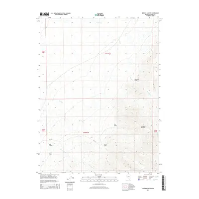
2014 Map of Bernice Canyon
USGS Topo · Published 2014About this map
The Clan Alpine Mountains dominate this high-desert landscape in Churchill County, where deeply incised drainages carve a complex system of canyons. This 2014 survey documents the hydrological relationship between the seasonal flows of Mud Spring Cr and Bernice Cr as they emerge from their respective namesake gorges, Mud Spring Canyon and Bernice Canyon. To the south, the terrain becomes increasingly intricate around Bob Canyon and Dyer Canyon, revealing the rugged natural topography of the Great Basin. The drainage patterns of Eagle Canyon Cr and the labels for Hoyt Canyon provide a detailed look at the arid watercourses that define this part of central Nevada, a region where the land's character is shaped by its extreme relief and remote western interior geography.
Find a feature on this map
15 named features on this map. Tap any name to fly to it.
Don’t see what you’re looking for? This feature index may not catch every label — zoom into the map to look around manually.
Map Details
Editions of this 2014 Bernice Canyon Map
This is the sole edition of this map. No revisions or reprints were ever made.
Other maps of this area

1955 · Millett
USGS Topo · 1:250,000

1959 · Millett
USGS Topo · 1:250,000

1966 · Clan Alpine Ranch
USGS Topo · 1:62,500

1966 · Humboldt Salt Marsh
USGS Topo · 1:62,500

1966 · Shoshone Meadows
USGS Topo · 1:62,500

1966 · Edwards Creek Valley
USGS Topo · 1:62,500

1983 · Edwards Creek Valley
USGS Topo · 1:100,000
1990 · Hole In The Wall
USGS Topo · 1:24,000
1990 · Bernice Canyon
USGS Topo · 1:24,000
1990 · Byers Canyon
USGS Topo · 1:24,000