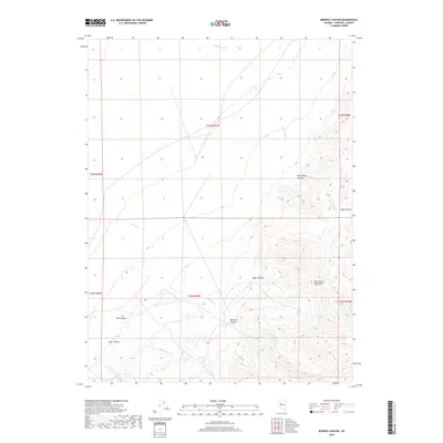
2018 Map of Bernice Canyon
USGS Topo · Published 2018About this map
The Clan Alpine Mountains dominate this high-desert landscape in Churchill County, where steep drainage patterns and narrow canyons define the local topography. The map detail highlights a series of seasonal watercourses, including Bernice Cr and Mud Spring Cr, which carve through the arid terrain. The presence of named geographic features such as Bernice Canyon and Hoyt Canyon suggests a history of local navigation and land use in this part of Nevada's Great Basin. The grid layout of public land survey townships like t23n r37e provides a structured framework over the natural folds of Bob Canyon and Dyer Canyon. This 2018 record shows a landscape shaped by intermittent water and high-elevation ridges, largely remote and unpopulated, serving as a primary reference for the physical geography of the range.
Find a feature on this map
15 named features on this map. Tap any name to fly to it.
Don’t see what you’re looking for? This feature index may not catch every label — zoom into the map to look around manually.
Map Details
Editions of this 2018 Bernice Canyon Map
This is the sole edition of this map. No revisions or reprints were ever made.
Other maps of this area

1955 · Millett
USGS Topo · 1:250,000

1959 · Millett
USGS Topo · 1:250,000

1966 · Clan Alpine Ranch
USGS Topo · 1:62,500

1966 · Humboldt Salt Marsh
USGS Topo · 1:62,500

1966 · Shoshone Meadows
USGS Topo · 1:62,500

1966 · Edwards Creek Valley
USGS Topo · 1:62,500

1983 · Edwards Creek Valley
USGS Topo · 1:100,000
1990 · Hole In The Wall
USGS Topo · 1:24,000
1990 · Bernice Canyon
USGS Topo · 1:24,000
1990 · Byers Canyon
USGS Topo · 1:24,000