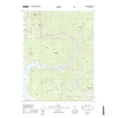
2018 Map of Berry Creek
USGS Topo · Published 2018About this map
The North Fork Feather River carves a deep canyon through this portion of the Sierra Nevada foothills, where the boundaries of the Lassen National Forest and Plumas National Forest meet. This 2018 survey documents a landscape defined by dramatic elevation changes, from the waters of Lake Oroville and Berry Creek Bar up to the heights of Big Bend Mtn and Chino Ridge. The infrastructure of the canyon is evident in the presence of Tunnel Number Seven and the winding path of the Blenzig Rxr Grade, reflecting the historical importance of rail transit through the Dark Canyon area. Small settlements and named locales like Poe, Parkhill, and Berry Creek are connected by a network of forest roads, including Bardess Bar Road and Pulga Rd, providing a detailed view of the region's contemporary rural development and forestry access.
Find a feature on this map
108 named features on this map. Tap any name to fly to it.
Don’t see what you’re looking for? This feature index may not catch every label — zoom into the map to look around manually.
Map Details
Editions of this 2018 Berry Creek Map
This is the sole edition of this map. No revisions or reprints were ever made.
Other maps of this area

1888 · Bidwell Bar
USGS Topo · 1:125,000

1891 · Bidwell Bar
USGS Topo · 1:125,000

1891 · Chico
USGS Topo · 1:125,000

1893 · Chico
USGS Topo · 1:125,000

1893 · Bidwell Bar
USGS Topo · 1:125,000

1895 · Bidwell Bar
USGS Topo · 1:125,000

1895 · Chico
USGS Topo · 1:125,000

1897 · Bidwell Bar
USGS Topo · 1:125,000

1912 · Oroville
USGS Topo · 1:31,680

1942 · Oroville
USGS Topo · 1:62,500