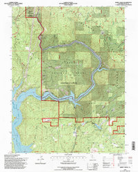
1994 Map of Berry Creek
USGS Topo · Published 1997About this map
The North Fork Feather River carves a deep path through the northern Sierra Nevada foothills, where industrial utility meets the rising waters of the Oroville State Recreation Area. In the north, the Poe Powerhouse and its associated Surge Tank and Substation signify the heavy hydro-infrastructure of the era, while the North Fork Feather River flows into the expansive Lake Oroville. Evidence of the region’s gold mining history is visible in the clusters of claims on Big Bend, including the Bunker Hill Mine, Suitcase Mine, and the Evering Star Mine. The community of Berry Creek serves as a small hub south of the river, anchored by the Berry Creek Sch and the nearby Madrone Lake, reflecting the scattered settlement patterns typical of these mountain-forest interfaces.
Find a feature on this map
66 named features on this map. Tap any name to fly to it.
Don’t see what you’re looking for? This feature index may not catch every label — zoom into the map to look around manually.
Map Details
Editions of this 1994 Berry Creek Map
This is the sole edition of this map. No revisions or reprints were ever made.
Other maps of this area

1888 · Bidwell Bar
USGS Topo · 1:125,000

1891 · Bidwell Bar
USGS Topo · 1:125,000

1891 · Chico
USGS Topo · 1:125,000

1893 · Chico
USGS Topo · 1:125,000

1893 · Bidwell Bar
USGS Topo · 1:125,000

1895 · Bidwell Bar
USGS Topo · 1:125,000

1895 · Chico
USGS Topo · 1:125,000

1897 · Bidwell Bar
USGS Topo · 1:125,000

1912 · Oroville
USGS Topo · 1:31,680

1942 · Oroville
USGS Topo · 1:62,500