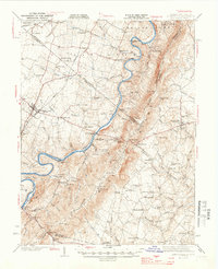
1944 Map of Berryville
USGS Topo · Published 1944About this map
Shenandoah River crossings and the dramatic rise of the Blue Ridge mountains dominate this mid-century portrait of the Virginia and West Virginia borderlands. The landscape transitions from the fertile valley floor near Berryville and Rippon to the steep slopes of Black Oak Ridge and Slate Ridge. Transportation is a central theme, with the Norfolk and Western and Baltimore and Ohio railroads serving agricultural hubs like Summit Point and Gaylord. Along the river, historic transit points like Boyds Ferry and the Castleman Ferry Bridge highlight the area's movement patterns before modern interstate expansion.
Find a feature on this map
90 named features on this map. Tap any name to fly to it.
Don’t see what you’re looking for? This feature index may not catch every label — zoom into the map to look around manually.
Map Details
Editions of this 1944 Berryville Map
This is the sole edition of this map. No revisions or reprints were ever made.
Other maps of this area

1884 · Harpers Ferry
USGS Topo · 1:125,000

1891 · Harpers Ferry
USGS Topo · 1:125,000

1893 · Luray
USGS Topo · 1:125,000

1893 · Harpers Ferry
USGS Topo · 1:125,000

1894 · Warrenton
USGS Topo · 1:125,000

1894 · Winchester
USGS Topo · 1:125,000

1905 · Luray
USGS Topo · 1:125,000

1908 · Middletown
USGS Topo · 1:48,000

1910 · Antietam
USGS Topo · 1:62,500

1914 · Martinsburg
USGS Topo · 1:48,000