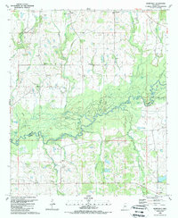
1989 Map of Berryville
USGS Topo · Published 1989About this map
The Big Black River forms a complex, winding boundary between Yazoo County and Madison County, creating a landscape defined by oxbow lakes and bottomlands. Significant water bodies such as Deadman Lake, Big Lake, and Ross Lake mark the former path of the river, while several smaller settlements like Fugate, Berryville, and Scotland are positioned on the higher ground surrounding the river valley. The area is notable for its numerous rural landmarks, including Beatties Bluff overlooking the river and a network of small community centers like Virillia.
Find a feature on this map
49 named features on this map. Tap any name to fly to it.
Don’t see what you’re looking for? This feature index may not catch every label — zoom into the map to look around manually.
Map Details
Editions of this 1989 Berryville Map
This is the sole edition of this map. No revisions or reprints were ever made.
Other maps of this area

1955 · Jackson
USGS Topo · 1:250,000

1961 · Jackson
USGS Topo · 1:250,000

1961 · Canton
USGS Topo · 1:62,500

1961 · Valley
USGS Topo · 1:62,500

1962 · Jackson
USGS Topo · 1:250,000

1962 · Flora
USGS Topo · 1:62,500

1964 · Linwood
USGS Topo · 1:24,000

1964 · Vaughan
USGS Topo · 1:24,000
1966 · Vaughan
USGS Topo · 1:62,500

1984 · Yazoo City
USGS Topo · 1:100,000