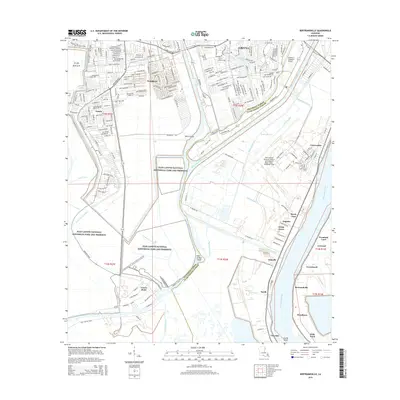
2015 Map of Bertrandville
USGS Topo · Published 2015About this map
The Mississippi River snakes through the eastern portion of this coastal Louisiana landscape, defining the agricultural and industrial corridor south of Gretna. Dense suburban developments like Woodmere and Estelle contrast sharply with the expansive wetlands of the Jean Lafitte National Historical Park and Preserve, which dominates the western half of the sheet. The region's intricate water management is visible through a complex network of man-made channels including the Intracoastal Waterway, Hero Cutoff, and Vendome Canal, all vital for navigation and drainage in the low-lying delta. Along the river's west bank, a string of historic settlements such as Oakville, Bertrandville, and Jesuits Bend follow the higher ground of the natural levee. This area also serves as a strategic military and aviation hub, anchored by the New Orleans Naval Air Station Joint Reserve Base and the Southern Seaplane Airport.
Find a feature on this map
51 named features on this map. Tap any name to fly to it.
Don’t see what you’re looking for? This feature index may not catch every label — zoom into the map to look around manually.
Map Details
Editions of this 2015 Bertrandville Map
This is the sole edition of this map. No revisions or reprints were ever made.
Other maps of this area

1891 · Pointe a La Hache
USGS Topo · 1:62,500

1891 · New Orleans
USGS Topo · 1:62,500

1892 · Barataria
USGS Topo · 1:62,500

1892 · St. Bernard
USGS Topo · 1:62,500

1892 · Pointe a La Hache
USGS Topo · 1:62,500

1932 · New Orleans NE
USGS Topo · 1:31,680

1932 · New Orleans NW
USGS Topo · 1:31,680

1932 · New Orleans SE
USGS Topo · 1:31,680

1932 · New Orleans SW
USGS Topo · 1:31,680
1938 · New Orleans West
USGS Topo · 1:31,680