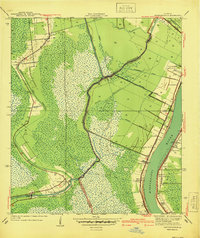
1940 Map of Bertrandville
USGS Topo · Published 1940About this map
The Mississippi River defines the eastern boundary of this lowland landscape, where the fertile natural levees supported established riverfront communities before the terrain dissolves into the back-swamp of the west. Narrow settlements like Bertrandville, Oakville, and Greenwood are tightly clustered along the river's curve, served by the Missouri Pacific and Southern Louisiana railroads. This era shows an intricate network of drainage and transport canals, including the Hero Canal and the Harvey Canal Waterway, which were essential for water management and commerce in the delta.
Find a feature on this map
36 named features on this map. Tap any name to fly to it.
Don’t see what you’re looking for? This feature index may not catch every label — zoom into the map to look around manually.
Map Details
Editions of this 1940 Bertrandville Map
This is the sole edition of this map. No revisions or reprints were ever made.
Other maps of this area

1891 · Pointe a La Hache
USGS Topo · 1:62,500

1891 · New Orleans
USGS Topo · 1:62,500

1892 · Barataria
USGS Topo · 1:62,500

1892 · St. Bernard
USGS Topo · 1:62,500

1892 · Pointe a La Hache
USGS Topo · 1:62,500

1932 · New Orleans NE
USGS Topo · 1:31,680

1932 · New Orleans NW
USGS Topo · 1:31,680

1932 · New Orleans SE
USGS Topo · 1:31,680

1932 · New Orleans SW
USGS Topo · 1:31,680
1938 · New Orleans West
USGS Topo · 1:31,680