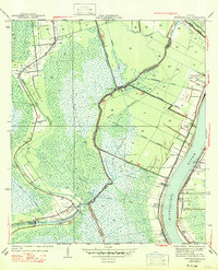
1947 Map of Bertrandville
USGS Topo · Published 1947About this map
Mississippi River transport and marshland drainage define this coastal landscape on the boundary of Jefferson Parish and Plaquemines Parish as it was surveyed just before World War II. The map details a transition from the industrial and agricultural riverbanks to the tidal wetlands of the west, where the Intracoastal Waterway cuts through numerous bayous like Bayou aux Carpes and Bayou des Familles. The concentration of life along the river is evident in a string of settlements including Bertrandville, Oakville, and Cedar Grove, all linked by the Missouri Pacific railroad.
Find a feature on this map
35 named features on this map. Tap any name to fly to it.
Don’t see what you’re looking for? This feature index may not catch every label — zoom into the map to look around manually.
Map Details
Editions of this 1947 Bertrandville Map
This is the sole edition of this map. No revisions or reprints were ever made.
Other maps of this area

1891 · Pointe a La Hache
USGS Topo · 1:62,500

1891 · New Orleans
USGS Topo · 1:62,500

1892 · Barataria
USGS Topo · 1:62,500

1892 · St. Bernard
USGS Topo · 1:62,500

1892 · Pointe a La Hache
USGS Topo · 1:62,500

1932 · New Orleans NE
USGS Topo · 1:31,680

1932 · New Orleans NW
USGS Topo · 1:31,680

1932 · New Orleans SE
USGS Topo · 1:31,680

1932 · New Orleans SW
USGS Topo · 1:31,680
1938 · New Orleans West
USGS Topo · 1:31,680