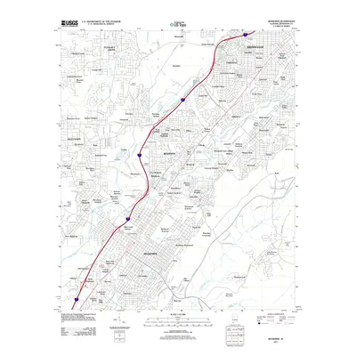
2011 Map of Bessemer
USGS Topo · Published 2011About this map
Opossum Valley serves as a major industrial and transportation corridor in this Jefferson County landscape during the early 21st century. The map documents the dense urban and residential expansion of Bessemer, Hueytown, and Pleasant Grove, alongside numerous smaller neighborhoods like Dolomite and Woodward. This era shows a complex network of rail infrastructure and heavy industry, anchored by the Elliott Yard and major junctions such as Blue Creek Junction and Dolonar Junction. Genealogists and local historians can find significant burial sites across the quadrangle, including the large Oakland Cemetery and Cedar Hill Cemetery. The transition from industrial peaks to suburban density is visible where the terrain rises toward Little Shades Mountain and Muscoda Mountain, reflecting the area's long history as an Alabama mining and manufacturing hub.
Find a feature on this map
220 named features on this map. Tap any name to fly to it.
Don’t see what you’re looking for? This feature index may not catch every label — zoom into the map to look around manually.
Map Details
Editions of this 2011 Bessemer Map
This is the sole edition of this map. No revisions or reprints were ever made.
Other maps of this area

1889 · Birmingham
USGS Topo · 1:125,000

1890 · Bessemer
USGS Topo · 1:125,000

1892 · Birmingham
USGS Topo · 1:125,000

1892 · Bessemer
USGS Topo · 1:125,000

1893 · Jasper
USGS Topo · 1:125,000

1895 · Birmingham
USGS Topo · 1:125,000

1899 · Brookwood
USGS Topo · 1:125,000

1904 · Birmingham Coal District
USGS Topo · 1:62,500

1905 · Bessemer Iron District
USGS Topo · 1:62,500

1906 · Birmingham Special
USGS Topo · 1:62,500