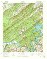
1968 Map of Bethel Valley
USGS Topo · Published 1972About this map
The U S Atomic Energy Commission Oak Ridge Area (Restricted) dominates this late 1960s landscape, illustrating the cold-war security infrastructure of Oak Ridge. The map details a complex industrial and research footprint, including a Sewage Disposal Plant and several pumping stations situated along the rugged ridges. This high-security zone is framed by the ridges of Bethel Ridge, Haw Ridge, and Chestnut Ridge, creating a physical isolation for the facility.
Find a feature on this map
46 named features on this map. Tap any name to fly to it.
Don’t see what you’re looking for? This feature index may not catch every label — zoom into the map to look around manually.
Map Details
Editions of this 1968 Bethel Valley Map
This is the sole edition of this map. No revisions or reprints were ever made.
Other maps of this area

1893 · Briceville
USGS Topo · 1:125,000

1895 · Loudon
USGS Topo · 1:125,000

1895 · Briceville
USGS Topo · 1:125,000

1896 · Briceville
USGS Topo · 1:125,000

1935 · Lenoir City
USGS Topo · 1:24,000

1935 · Elverton
USGS Topo · 1:24,000

1935 · Bethel Valley
USGS Topo · 1:24,000

1935 · Lovell
USGS Topo · 1:24,000

1936 · Cave Creek
USGS Topo · 1:24,000

1936 · Windrock
USGS Topo · 1:24,000