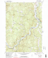
1980 Map of Bethel
USGS Topo · Published 1990About this map
Gaysville and Riverside sit along the winding course of the White River, serving as focal points for this 1980s-era map of Windsor County. The landscape is defined by the confluence of numerous waterways, including Locust Creek, Stony Brook, and the Third Branch White River, which carve through the high terrain of Vulture Mtn and Delectable Mtn. Local infrastructure and community life are well-documented through labels for the White River National Fish Hatchery, the Drive-in Theater near the northern boundary, and educational facilities like Whitcomb High Sch. Genealogists will find significant value in the mapped locations of several cemeteries, including the Sylvester Plot Cem and Abbot Cem. The map captures a moment when traditional valley settlements like Lilliesville and Lympus remained anchored by the geography of gaps and hills.
Find a feature on this map
61 named features on this map. Tap any name to fly to it.
Don’t see what you’re looking for? This feature index may not catch every label — zoom into the map to look around manually.
Map Details
Editions of this 1980 Bethel Map
3 editions found
Other maps of this area

1891 · Rutland
USGS Topo · 1:62,500

1893 · Rutland
USGS Topo · 1:62,500

1911 · Woodstock
USGS Topo · 1:62,500

1913 · Woodstock
USGS Topo · 1:62,500

1915 · Rochester
USGS Topo · 1:62,500

1917 · Rochester
USGS Topo · 1:62,500

1919 · Royalton
USGS Topo · 1:62,500

1924 · Randolph
USGS Topo · 1:48,000

1926 · Randolph
USGS Topo · 1:62,500

1943 · Woodstock
USGS Topo · 1:62,500