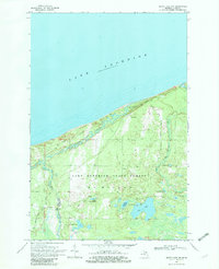
1968 Map of Betsy Lake NW
USGS Topo · Published 1982About this map
Lake Superior dominates the northern reaches of this survey, defining a coastline shaped by the complex drainage of the Two Hearted River. Inland, the landscape of the Lake Superior State Forest in McMillan Township is characterized by numerous kettle lakes and a network of informal transport routes, including the Coast Guard Road and various Jeep Trails. The interior is marked by significant water bodies such as Pike Lake, Homestead Lake, and the winding course of the Little Two Hearted River. This 1960s mapping reveals a wilderness area maintained for conservation and light recreation, evidenced by the Landing Field near Landing Road and the absence of dense residential development, preserving a specific mid-century view of Michigan's Upper Peninsula.
Find a feature on this map
19 named features on this map. Tap any name to fly to it.
Don’t see what you’re looking for? This feature index may not catch every label — zoom into the map to look around manually.
Map Details
Editions of this 1968 Betsy Lake NW Map
2 editions found
Other maps of this area

1954 · Sault Sainte Marie
USGS Topo · 1:250,000

1956 · Sault Sainte Marie
USGS Topo · 1:250,000

1957 · Sault Sainte Marie
USGS Topo · 1:250,000

1958 · Sault Sainte Marie
USGS Topo · 1:250,000

1968 · Muskallonge Lake East
USGS Topo · 1:24,000
1968 · Betsy Lake North
USGS Topo · 1:24,000

1968 · Muskallonge Lake SE
USGS Topo · 1:24,000

1968 · Betsy Lake NW
USGS Topo · 1:24,000

1968 · Betsy Lake SW
USGS Topo · 1:24,000
1968 · Betsy Lake South
USGS Topo · 1:24,000