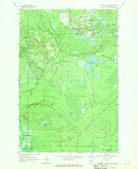
1968 Map of Betsy Lake SW
USGS Topo · Published 1971About this map
The northern Upper Peninsula's wild timberlands and waterways are meticulously documented in this 1968 field-checked survey of McMillan township. The landscape is defined by the hydrologic network of the East Branch Two Hearted River and Little Two Hearted River, weaving through the Lake Superior State Forest. The map captures a moment when the regional economy transitioned from heavy rail to logging roads, evidenced by the presence of an Old Railroad Grade and the development of the Fossitt Logging Road and West Fossitt Logging Road. Local landmarks like Chesbrough Lake and the Little Two Hearted Lakes provide specific points of interest for those studying the area's geography. To the south, the boundary of the Tahquamenon River State Forest indicates the vast protected timber reserves that characterize this part of Luce County.
Find a feature on this map
18 named features on this map. Tap any name to fly to it.
Don’t see what you’re looking for? This feature index may not catch every label — zoom into the map to look around manually.
Map Details
Editions of this 1968 Betsy Lake SW Map
2 editions found
Other maps of this area

1954 · Sault Sainte Marie
USGS Topo · 1:250,000

1956 · Sault Sainte Marie
USGS Topo · 1:250,000

1957 · Sault Sainte Marie
USGS Topo · 1:250,000

1958 · Sault Sainte Marie
USGS Topo · 1:250,000

1962 · Auger Lake
USGS Topo · 1:24,000

1968 · Muskallonge Lake East
USGS Topo · 1:24,000
1968 · Betsy Lake North
USGS Topo · 1:24,000

1968 · Muskallonge Lake SE
USGS Topo · 1:24,000

1968 · Betsy Lake NW
USGS Topo · 1:24,000

1968 · Betsy Lake SW
USGS Topo · 1:24,000