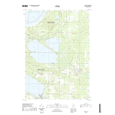
2019 Map of Beulah
USGS Topo · Published 2019About this map
Sleeping Bear Dunes National Lakeshore dominates the northern reaches of this Benzie County landscape, where the glacial legacy is written in a series of major water bodies. From the expansive Crystal Lake in the southwest to the coastal waters of Platte Bay and Lake Michigan, the map reveals a region defined by its shoreline and resort character. The village of Beulah sits at the head of Crystal Lake, serving as a hub alongside nearby Benzonia. Farther east, the community of Honor is situated near the Platte River, which meanders through a low-lying wetland corridor connecting Little Platte Lake and the primary Platte Lake. Cultural landmarks like the Champion Hill Cem and Aral Lodge provide specific points of interest for local historians, while the Benzie County Government Center marks the administrative heart of the county.
Find a feature on this map
93 named features on this map. Tap any name to fly to it.
Don’t see what you’re looking for? This feature index may not catch every label — zoom into the map to look around manually.
Map Details
Editions of this 2019 Beulah Map
This is the sole edition of this map. No revisions or reprints were ever made.
Other maps of this area

1954 · Traverse City
USGS Topo · 1:250,000

1954 · Manitowoc
USGS Topo · 1:250,000

1956 · Thompsonville
USGS Topo · 1:62,500

1956 · Frankfort
USGS Topo · 1:62,500

1957 · Empire
USGS Topo · 1:62,500

1957 · Maple City
USGS Topo · 1:62,500

1958 · Traverse City
USGS Topo · 1:250,000

1958 · Manitowoc
USGS Topo · 1:250,000

1976 · Frankfort SE
USGS Topo · 1:24,000

1976 · Frankfort NW
USGS Topo · 1:24,000