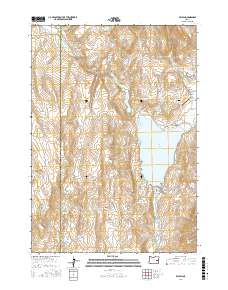
2017 Map of Beulah
USGS Topo · Published 2017About this map
Beulah Reservoir dominates this high-desert landscape in eastern Oregon, serving as a critical water management feature for the region. The small settlement of Beulah sits south of the dam, while the broader Agency Valley contains local historical markers like the Agency Valley Cem and the Murphy Ranch Airport. The terrain is defined by the winding course of the North Fork Malheur River and the numerous springs that dot the hillsides, including Charcoal Spring and Fox Spring. The boundary between Harney County and Malheur County cuts through the western portion of the map, illustrating the remote jurisdictional lines in this part of the state. Prominent landforms such as Agency Mtn and Jerry Canyon create a complex topography of ridges and gulches that have long shaped ranching and transportation routes.
Find a feature on this map
35 named features on this map. Tap any name to fly to it.
Don’t see what you’re looking for? This feature index may not catch every label — zoom into the map to look around manually.
Map Details
Editions of this 2017 Beulah Map
This is the sole edition of this map. No revisions or reprints were ever made.
Other maps of this area

1908 · Ironside Mountain
USGS Topo · 1:125,000

1955 · Burns
USGS Topo · 1:250,000

1955 · Canyon City
USGS Topo · 1:250,000

1958 · Burns
USGS Topo · 1:250,000

1959 · Burns
USGS Topo · 1:250,000

1959 · Canyon City
USGS Topo · 1:250,000

1966 · Beulah
USGS Topo · 1:62,500

1968 · Drewsey
USGS Topo · 1:62,500

1970 · Flag Prairie
USGS Topo · 1:62,500

1970 · Castle Rock
USGS Topo · 1:62,500