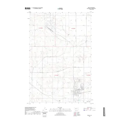
2018 Map of Beulah
USGS Topo · Published 2018About this map
Beulah serves as the focal point of this North Dakota landscape, situated at the confluence of the Knife River and Spring Cr. The town's grid is dense with residential and civic infrastructure, including the Zion Lutheran Church and the Beulah Airport to the south. The surrounding terrain of the Williston Basin is characterized by the winding paths of the W Br Antelope Cr and numerous family cemeteries that dot the prairie, such as the Boeckel Cem and Zaron Cem. These burial grounds, alongside the Beulah City Cem and Zion Lutheran Church Cem, provide significant markers for genealogical research in Mercer County. The southern edge of the map is defined by the proximity of Wally Dresskell Lake and the river's path, showing the town's relationship to these vital water sources.
Find a feature on this map
41 named features on this map. Tap any name to fly to it.
Don’t see what you’re looking for? This feature index may not catch every label — zoom into the map to look around manually.
Map Details
Editions of this 2018 Beulah Map
This is the sole edition of this map. No revisions or reprints were ever made.
Other maps of this area

1954 · McClusky
USGS Topo · 1:250,000

1958 · McClusky
USGS Topo · 1:250,000

1968 · Beulah
USGS Topo · 1:24,000

1968 · Medicine Butte NE
USGS Topo · 1:24,000

1968 · Red Butte NW
USGS Topo · 1:24,000

1968 · Hazen West
USGS Topo · 1:24,000

1968 · Medicine Butte
USGS Topo · 1:24,000

1969 · Beulah NE
USGS Topo · 1:24,000
1969 · Hazen NW
USGS Topo · 1:24,000
1969 · Beulah NW
USGS Topo · 1:24,000