
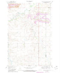
1968 Map of Medicine Butte NE
USGS Topo · Published 1969About this map
Industrial extraction and infrastructure planning define this late-1960s landscape along the border of Mercer and Oliver Counties. Massive Strip Mine operations dominate the northern reaches, while the Northern Pacific railroad tracks follow the winding course of the Knife River. An interesting glimpse into mid-century regional water management is found near the river's bend, where the site of the Proposed Beulah Dam is marked, suggesting a potential transformation of the river valley. The map also documents local aviation with a Landing Strip and the Municipal Airport. Genealogists will find the exact locations of Rose Hill Cem and Emmaus Cem, while smaller watercourses like Brush Creek and Coyote Creek provide a framework for the rural topography south of the mining activity.
Find a feature on this map
13 named features on this map. Tap any name to fly to it.
Don’t see what you’re looking for? This feature index may not catch every label — zoom into the map to look around manually.
Map Details
Editions of this 1968 Medicine Butte NE Map
2 editions found
Other maps of this area

1954 · McClusky
USGS Topo · 1:250,000

1958 · McClusky
USGS Topo · 1:250,000

1968 · Beulah
USGS Topo · 1:24,000

1968 · Red Butte NW
USGS Topo · 1:24,000

1968 · Hazen West
USGS Topo · 1:24,000

1968 · Medicine Butte
USGS Topo · 1:24,000

1969 · Zap
USGS Topo · 1:24,000
1972 · Medicine Butte SW
USGS Topo · 1:24,000
1972 · Red Butte SW
USGS Topo · 1:24,000
1972 · Medicine Butte SE
USGS Topo · 1:24,000