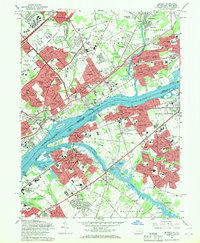
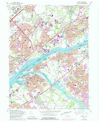
1966 Map of Beverly
USGS Topo · Published 1969About this map
The Delaware River serves as the central artery for this mid-1960s landscape, dividing the urbanizing reaches of Philadelphia and Bucks Co, Pennsylvania, from the riverfront communities of Burlington Co, New Jersey. The Pennsylvania side is densely developed, dominated by institutions like the Philadelphia State Hospital and the County Prison Farm, alongside the sprawling Liberty Bell Park and North Philadelphia Airport. This period captures the post-war suburban surge in neighborhoods such as Croydon, Edgewater Park, and Willingboro, where new street grids and schools like John F Kennedy High Sch and Abraham Levitt High Sch replaced earlier agricultural patterns.
Find a feature on this map
143 named features on this map. Tap any name to fly to it.
Don’t see what you’re looking for? This feature index may not catch every label — zoom into the map to look around manually.
Map Details
Editions of this 1966 Beverly Map
5 editions found
Other maps of this area

1888 · Mount Holly
USGS Topo · 1:62,500

1890 · Burlington
USGS Topo · 1:62,500

1891 · Philadelphia
USGS Topo · 1:62,500

1893 · Germantown
USGS Topo · 1:62,500

1893 · Burlington
USGS Topo · 1:62,500

1894 · Mount Holly
USGS Topo · 1:62,500

1894 · Philadelphia
USGS Topo · 1:62,500

1894 · Germantown
USGS Topo · 1:62,500

1896 · Germantown
USGS Topo · 1:62,500

1896 · Philadelphia
USGS Topo · 1:62,500
Featured Places
- Philadelphia, PA
- Bensalem Township, PA
- Mount Laurel Township, NJ
- Willingboro Township, NJ
- Moorestown Township, NJ