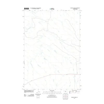
2012 Map of Beverly Creek
USGS Topo · Published 2012About this map
S Fork Moreau River and its meandering tributaries define the drainage patterns of this rural landscape in Meade County. Small, seasonal watercourses including Beverly Cr and Frozen Man Cr carve through the terrain, illustrating the hydrologic character of the western South Dakota plains. Settlement is sparse, represented primarily by the intermittent road network that connects these remote grazing lands. Vital access is provided by thoroughfares such as Zeona Rd and 165th Ave, which follow the section lines and natural contours between drainage basins. To the south, Trail Cr and Spring Cr feed into the broader regional water system, marking the quiet, open geography of the high plains before the modern era of expansion reached this corner of the state.
Find a feature on this map
8 named features on this map. Tap any name to fly to it.
Don’t see what you’re looking for? This feature index may not catch every label — zoom into the map to look around manually.
Map Details
Editions of this 2012 Beverly Creek Map
This is the sole edition of this map. No revisions or reprints were ever made.
Other maps of this area

1951 · Cedar Canyon
USGS Topo · 1:24,000

1951 · Imogene
USGS Topo · 1:24,000

1953 · Rapid City
USGS Topo · 1:250,000

1954 · Lemmon
USGS Topo · 1:250,000

1957 · Lemmon
USGS Topo · 1:250,000

1957 · Rapid City
USGS Topo · 1:250,000

1973 · Frozen Man Creek
USGS Topo · 1:24,000
1978 · Camp Creek
USGS Topo · 1:24,000

1980 · Beverly Creek
USGS Topo · 1:25,000

1980 · Zeona
USGS Topo · 1:25,000