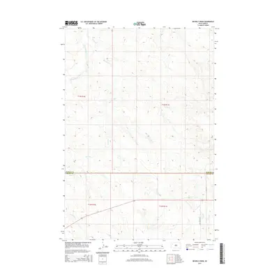
2015 Map of Beverly Creek
USGS Topo · Published 2015About this map
The S Fork Moreau River system defines this corner of South Dakota, where the landscape is sculpted by a series of seasonal drainages. In the northern sections, the river and its namesake Beverly Cr carve through the terrain, while the southern portion of the quadrangle is dominated by the headwaters of Frozen Man Cr, Trail Cr, and Spring Cr. This area sits at the intersection of the Perkins and Meade county lines, illustrating a remote prairie environment where transportation is limited to a few established routes such as 165th Ave and Eagle Township Rd. The map provides a detailed view of the township and range survey system, showing the precise divisions of t13n r10e, t13n r11e, and their southern counterparts, which are essential for tracing land ownership and ranching boundaries in this sparsely populated region.
Find a feature on this map
12 named features on this map. Tap any name to fly to it.
Don’t see what you’re looking for? This feature index may not catch every label — zoom into the map to look around manually.
Map Details
Editions of this 2015 Beverly Creek Map
This is the sole edition of this map. No revisions or reprints were ever made.
Other maps of this area

1951 · Cedar Canyon
USGS Topo · 1:24,000

1951 · Imogene
USGS Topo · 1:24,000

1953 · Rapid City
USGS Topo · 1:250,000

1954 · Lemmon
USGS Topo · 1:250,000

1957 · Lemmon
USGS Topo · 1:250,000

1957 · Rapid City
USGS Topo · 1:250,000

1973 · Frozen Man Creek
USGS Topo · 1:24,000
1978 · Camp Creek
USGS Topo · 1:24,000

1980 · Beverly Creek
USGS Topo · 1:25,000

1980 · Zeona
USGS Topo · 1:25,000