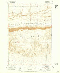
1954 Map of Beverly SE
USGS Topo · Published 1955About this map
Saddle Mountains dominate this mid-century landscape along the Washington-Grant County line, rising sharply above the desert floor. The northern portion of the map is defined by the east-west corridor of Crab Creek, where the Chicago Milwaukee St Paul and Pacific railroad tracks parallel the water. Near the settlement of Jericho, the landscape transitions from the creek basin to the high peaks of Sentinel Mtn. This area reflects a mid-1950s snapshot of central Washington's rugged rangeland, marked by isolated infrastructure like a Windmill, several Water Tank sites, and a Well. The southern half of the sheet descends into the Wahluke Slope, showing the transition from the high ridges of the mountains down toward the open plains. Evidence of early land use is scattered throughout the terrain, including a Mine north of the mountains and the lone Wilson Spr in the northern coulee.
Find a feature on this map
13 named features on this map. Tap any name to fly to it.
Don’t see what you’re looking for? This feature index may not catch every label — zoom into the map to look around manually.
Map Details
Editions of this 1954 Beverly SE Map
This is the sole edition of this map. No revisions or reprints were ever made.
Other maps of this area

1911 · Red Rock
USGS Topo · 1:62,500

1912 · Beverly
USGS Topo · 1:62,500

1916 · Coyote Rapids
USGS Topo · 1:62,500

1917 · Priest Rapids
USGS Topo · 1:62,500

1948 · Priest Rapids
USGS Topo · 1:24,000

1950 · Smyrna
USGS Topo · 1:62,500

1951 · Priest Rapids
USGS Topo · 1:62,500

1951 · Smyrna
USGS Topo · 1:62,500

1951 · Coyote Rapids
USGS Topo · 1:62,500

1953 · Walla Walla
USGS Topo · 1:250,000