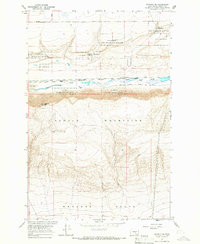
1965 Map of Beverly SE
USGS Topo · Published 1966About this map
Columbia National Wildlife Refuge dominates the northern reaches of this mid-1960s landscape, where the waters of Lower Crab Creek and Wilson Spring support a vital wetland corridor in an otherwise arid environment. This region of Grant County is defined by dramatic elevation changes, from the alluvial flats near Jericho to the heights of the Saddle Mountains and Sentinel Mtn. The Chicago Milwaukee St Paul and Pacific railroad follows the low-lying creek bed, providing a critical transportation link through the valley. South of the mountain ridge, the land transitions into the broad Wahluke Slope, showcasing the distinct geomorphology of the Columbia Basin. Human infrastructure is sparse but notable, including a Gaging Station on the creek and a Radio Facility perched atop the mountain heights.
Find a feature on this map
17 named features on this map. Tap any name to fly to it.
Don’t see what you’re looking for? This feature index may not catch every label — zoom into the map to look around manually.
Map Details
Editions of this 1965 Beverly SE Map
This is the sole edition of this map. No revisions or reprints were ever made.
Other maps of this area

1911 · Red Rock
USGS Topo · 1:62,500

1912 · Beverly
USGS Topo · 1:62,500

1916 · Coyote Rapids
USGS Topo · 1:62,500

1917 · Priest Rapids
USGS Topo · 1:62,500

1948 · Priest Rapids
USGS Topo · 1:24,000

1950 · Smyrna
USGS Topo · 1:62,500

1951 · Priest Rapids
USGS Topo · 1:62,500

1951 · Smyrna
USGS Topo · 1:62,500

1951 · Coyote Rapids
USGS Topo · 1:62,500

1953 · Walla Walla
USGS Topo · 1:250,000