
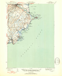
1941 Map of Biddeford
USGS Topo · Published 1952About this map
The Saco River serves as the dividing line between the twin cities of Saco and Biddeford in this 1941 survey of the Maine coastline. The urban centers, linked by the Boston and Maine Railroad, contrast with the expansive wetlands of the Big Heath and the intricate rocky shorelines of Kennebunkport and Cape Porpoise. Coastal life is defined by protected waters like The Pool and Wood Island Harbor, where a Coast Guard Station stands watch over the Atlantic approaches. Local educational and religious institutions are well-documented, from the riverside St Francis College and Stella Maris Sch to several rural schoolhouses such as Guinea Road Sch and Nott Sch. The map records a landscape of seasonal summer communities at Ocean Park and Camp Ellis before mid-century development further altered the York County shore.
Find a feature on this map
68 named features on this map. Tap any name to fly to it.
Don’t see what you’re looking for? This feature index may not catch every label — zoom into the map to look around manually.
Map Details
Editions of this 1941 Biddeford Map
2 editions found
Other maps of this area

1891 · Portland
USGS Topo · 1:62,500

1891 · Biddeford
USGS Topo · 1:62,500

1891 · Kennebunk
USGS Topo · 1:62,500

1891 · Buxton
USGS Topo · 1:62,500

1892 · Buxton
USGS Topo · 1:62,500

1893 · Kennebunk
USGS Topo · 1:62,500

1893 · York
USGS Topo · 1:62,500

1893 · Biddeford
USGS Topo · 1:62,500

1893 · Portland
USGS Topo · 1:62,500

1893 · Casco Bay
USGS Topo · 1:62,500