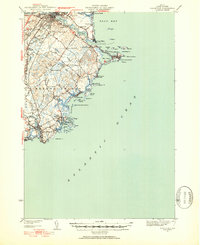
1941 Map of Biddeford
USGS Topo · Published 1952About this map
The industrial and maritime hubs of Saco and Biddeford dominate the northern reach of this 1941 survey, where the Saco River empties into Saco Bay. This era shows a landscape transitioning between its manufacturing roots and its growing identity as a coastal destination, with the Boston and Maine Railroad cutting through the interior while clusters of summer cottages and local landmarks like Camp Ellis and Biddeford Pool line the Atlantic shore. Genealogists can locate numerous local institutions, from the Laurel Hill Cem to the Stella Maris Sch and St Francis College. Further south, the map details the intricate tidal inlets and islands around Kennebunkport and Cape Porpoise, including landmarks like The Pool and the Coast Guard Station on Fletcher Neck. The interior remains largely rural, dotted with district schools such as the Noll Sch and the Hutchins Sch.
Find a feature on this map
72 named features on this map. Tap any name to fly to it.
Don’t see what you’re looking for? This feature index may not catch every label — zoom into the map to look around manually.
Map Details
Editions of this 1941 Biddeford Map
2 editions found

Other maps of this area

1891 · Portland
USGS Topo · 1:62,500

1891 · Biddeford
USGS Topo · 1:62,500

1891 · Kennebunk
USGS Topo · 1:62,500

1891 · Buxton
USGS Topo · 1:62,500

1892 · Buxton
USGS Topo · 1:62,500

1893 · Kennebunk
USGS Topo · 1:62,500

1893 · York
USGS Topo · 1:62,500

1893 · Biddeford
USGS Topo · 1:62,500

1893 · Portland
USGS Topo · 1:62,500

1893 · Casco Bay
USGS Topo · 1:62,500