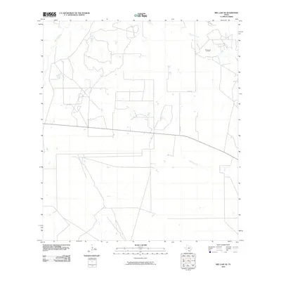
2010 Map of Biel Lake NE
USGS Topo · Published 2010About this map
Charamusca Oil Field dominates the northeastern corner of this South Texas landscape, illustrating the intersection of energy extraction and ranching in Webb County. The terrain is defined by a dendritic network of intermittent drainages, most notably Charamusca Creek and Colmena Creek, which flow toward the southeast. These watercourses shape the placement of rural infrastructure, as seen where Co Rd 401 navigates the open country between established well sites. This 2010 survey reflects the modern industrial footprint in a region where traditional land use meets the demands of the oil and gas industry, providing a clear record of the access roads and surface developments essential to the field's operation near Black Creek.
Find a feature on this map
5 named features on this map. Tap any name to fly to it.
Don’t see what you’re looking for? This feature index may not catch every label — zoom into the map to look around manually.
Map Details
Editions of this 2010 Biel Lake NE Map
This is the sole edition of this map. No revisions or reprints were ever made.
Other maps of this area

1937 · Loma Alta
USGS Topo · 1:62,500

1953 · Crystal City
USGS Topo · 1:250,000

1955 · Crystal City
USGS Topo · 1:250,000

1956 · Freer
USGS Topo · 1:62,500

1956 · Piedra Creek
USGS Topo · 1:62,500

1956 · Las Mujeres
USGS Topo · 1:62,500

1956 · Laredo
USGS Topo · 1:250,000

1961 · Crystal City
USGS Topo · 1:250,000

1968 · Crystal City
USGS Topo · 1:250,000
1969 · Mirasol Creek
USGS Topo · 1:24,000