1969 Map of Mirasol Creek
USGS Topo · Published 1972About this map
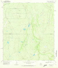
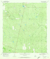
The U S Naval Reservation dominates the northern landscape of this Texas brush country survey, marked by a Control Tower and multiple Observation Tower sites. This military presence sits alongside the natural drainage of the Old Nueces River Channel, which defines the far northwestern corner of the quadrangle. The terrain is characterized by a network of intermittent waterways, including Mirasol Creek, Ygnacio Creek, and Juanita Creek, which flow through the arid landscape toward the Duval County line.
Find a feature on this map
16 named features on this map. Tap any name to fly to it.
Don’t see what you’re looking for? This feature index may not catch every label — zoom into the map to look around manually.
Map Details
Editions of this 1969 Mirasol Creek Map
2 editions found

Other maps of this area
1937 · Loma Alta
USGS Topo · 1:62,500

1953 · Crystal City
USGS Topo · 1:250,000

1955 · Crystal City
USGS Topo · 1:250,000
1956 · Freer
USGS Topo · 1:62,500

1956 · Piedra Creek
USGS Topo · 1:62,500

1956 · Las Mujeres
USGS Topo · 1:62,500

1956 · Laredo
USGS Topo · 1:250,000

1961 · Crystal City
USGS Topo · 1:250,000

1968 · Crystal City
USGS Topo · 1:250,000
1969 · Loma Alta NE
USGS Topo · 1:24,000