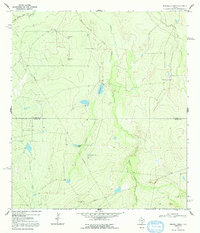
1969 Map of Mirasol Creek
USGS Topo · Published 1992About this map
The Old Nueces River Channel cuts through the northern reaches of this brush country landscape, marking the transition into the ranchlands of McMullen and Duval counties. Surveyed in the late 1960s, the terrain is defined by a network of drainage systems including Ygnacio Creek, San Jose Creek, and the central Mirasol Creek. Human impact on the arid environment is visible through the strategic placement of water features such as Rowland Tank, Pulgas Tank, and Pipeline Tank, essential for supporting livestock at locations like Walker Ranch. Industrial activity is noted in the southern portion of the sheet with scattered Oil Wells, while the presence of a Control Tower and Observation Tower in the northwest suggests a specialized use of this open territory. The boundary between McMullen and Duval counties bisects the quadrangle, providing a precise reference for land ownership and local jurisdiction during this era.
Find a feature on this map
16 named features on this map. Tap any name to fly to it.
Don’t see what you’re looking for? This feature index may not catch every label — zoom into the map to look around manually.
Map Details
Editions of this 1969 Mirasol Creek Map
2 editions found
Other maps of this area

1937 · Loma Alta
USGS Topo · 1:62,500

1953 · Crystal City
USGS Topo · 1:250,000

1955 · Crystal City
USGS Topo · 1:250,000

1956 · Freer
USGS Topo · 1:62,500

1956 · Piedra Creek
USGS Topo · 1:62,500

1956 · Las Mujeres
USGS Topo · 1:62,500

1956 · Laredo
USGS Topo · 1:250,000

1961 · Crystal City
USGS Topo · 1:250,000

1968 · Crystal City
USGS Topo · 1:250,000
1969 · Loma Alta NE
USGS Topo · 1:24,000