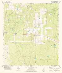
1974 Map of Biel Lake NE
USGS Topo · Published 1977About this map
The Charamusca Oil Field dominates this South Texas landscape along the Webb and Duval county line during the mid-1970s. This industrial corridor is defined by an extensive network of pipelines, access roads, and numerous oil wells, reflecting the intensive energy extraction characteristic of the Brush Country. A central refinery and associated pumping station serve as local hubs for production, while a substation and radio tower mark the technical infrastructure required to maintain operations across the wide-open terrain. Away from the drilling sites, the natural drainage patterns of Colmena Creek, Black Creek, and Charamusca Creek cut through the landscape, providing a sharp contrast to the geometric lines of the resource extraction industry. The map captures a specific moment in the evolution of these Texas oil lands, documenting everything from scattered drill holes to active gravel pits.
Find a feature on this map
15 named features on this map. Tap any name to fly to it.
Don’t see what you’re looking for? This feature index may not catch every label — zoom into the map to look around manually.
Map Details
Editions of this 1974 Biel Lake NE Map
This is the sole edition of this map. No revisions or reprints were ever made.
Other maps of this area

1937 · Loma Alta
USGS Topo · 1:62,500

1953 · Crystal City
USGS Topo · 1:250,000

1955 · Crystal City
USGS Topo · 1:250,000

1956 · Freer
USGS Topo · 1:62,500

1956 · Piedra Creek
USGS Topo · 1:62,500

1956 · Las Mujeres
USGS Topo · 1:62,500

1956 · Laredo
USGS Topo · 1:250,000

1961 · Crystal City
USGS Topo · 1:250,000

1968 · Crystal City
USGS Topo · 1:250,000
1969 · Mirasol Creek
USGS Topo · 1:24,000