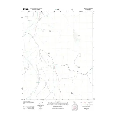
2012 Map of Big Alkali
USGS Topo · Published 2012About this map
Willow Springs and the small outpost of Dog Town anchor this 2012 survey of the high desert and mountain interface in Mono County. The landscape is defined by its thermal activity and water sources, including Travertine Hot Spring and The Hot Spring near Hot Springs Canyon. Geologic and early industrial markers are scattered throughout, such as the Dynamo Pond and the mineral-named Cinnabar Canyon. To the north, the E Walker River flows through the Bridgeport Valley, while the western edge is marked by the heights of Potato Peak. Grazing and ranching history is evident in named meadows like Mormon Meadow and Lower Summers Meadows, and the central hub of Point Ranch. This survey provides a clear look at the intersection of local mountain roads and the natural drainage systems of Virginia Cr and Clearwater Cr.
Find a feature on this map
26 named features on this map. Tap any name to fly to it.
Don’t see what you’re looking for? This feature index may not catch every label — zoom into the map to look around manually.
Map Details
Editions of this 2012 Big Alkali Map
This is the sole edition of this map. No revisions or reprints were ever made.
Other maps of this area

1909 · Bridgeport
USGS Topo · 1:125,000

1911 · Bridgeport
USGS Topo · 1:125,000

1920 · Bridgeport
USGS Topo · 1:125,000

1948 · Walker Lake
USGS Topo · 1:250,000

1956 · Fales Hot Springs
USGS Topo · 1:62,500

1956 · Matterhorn Peak
USGS Topo · 1:62,500

1957 · Walker Lake
USGS Topo · 1:250,000

1958 · Bodie
USGS Topo · 1:62,500
1958 · Bridgeport
USGS Topo · 1:62,500

1962 · Walker Lake
USGS Topo · 1:250,000