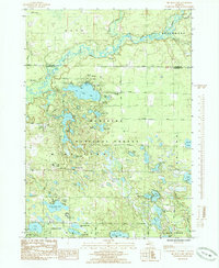
1985 Map of Big Blue Lake
USGS Topo · Published 1985About this map
The White River winds through the northern reaches of this landscape, fed by the North Branch and South Branch within the dense canopy of the Manistee National Forest. This mid-1980s survey illustrates a region defined by its glacial lakes and outdoor recreation, centered around the village of Lakewood Club and the sprawling waters of Big Blue Lake. The concentration of recreational sites, including Camp Pendalouah, the Oak-Hill County Campground, and Blue Lake County Park, indicates the area's significance as a destination for summer residency and youth camps.
Find a feature on this map
53 named features on this map. Tap any name to fly to it.
Don’t see what you’re looking for? This feature index may not catch every label — zoom into the map to look around manually.
Map Details
Editions of this 1985 Big Blue Lake Map
This is the sole edition of this map. No revisions or reprints were ever made.
Other maps of this area

1929 · Montague
USGS Topo · 1:48,000

1931 · Hart SE
USGS Topo · 1:31,680

1931 · Walkerville SW
USGS Topo · 1:31,680

1931 · Walkerville SE
USGS Topo · 1:31,680

1954 · Milwaukee
USGS Topo · 1:250,000

1958 · Milwaukee
USGS Topo · 1:250,000

1958 · Hesperia
USGS Topo · 1:62,500

1958 · Twin Lake
USGS Topo · 1:62,500

1959 · Montague
USGS Topo · 1:62,500

1959 · Hart
USGS Topo · 1:62,500