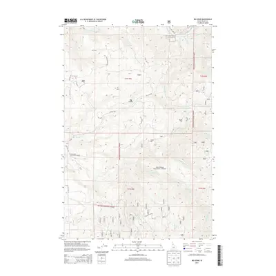
2013 Map of Big Cedar
USGS Topo · Published 2013About this map
The Middle Fork Clearwater River defines the northern edge of this Idaho County landscape, where the rugged terrain transitions from the river valley to the heights of Nez Perce National Forest. The small settlement of Tahoe sits along the elevated Tahoe Ridge, marked by the Tahoe Cem and access via Cemetery RD. To the south, the community of Big Cedar is established near the confluence of several mountain streams including Big Cedar Cr and Little Cedar Cr. This area is characterized by significant topographic shifts, rising toward distinctive landmarks like The Horn, Crane Hill, and Potato Hill. The presence of the Clear Creek International Airport near Clear Cr provides a modern navigational point amidst a network of forest service roads such as NFD 1842 RD and Clear Creek Loop RD.
Find a feature on this map
44 named features on this map. Tap any name to fly to it.
Don’t see what you’re looking for? This feature index may not catch every label — zoom into the map to look around manually.
Map Details
Editions of this 2013 Big Cedar Map
This is the sole edition of this map. No revisions or reprints were ever made.
Other maps of this area

1924 · Weippe
USGS Topo · 1:125,000

1931 · Buffalo Hump
USGS Topo · 1:125,000

1934 · Buffalo Hump
USGS Topo · 1:125,000

1956 · Elk City
USGS Topo · 1:250,000

1956 · Hamilton
USGS Topo · 1:250,000

1959 · Hamilton
USGS Topo · 1:250,000

1960 · Elk City
USGS Topo · 1:250,000

1960 · Hamilton
USGS Topo · 1:250,000

1962 · Pilot Knob
USGS Topo · 1:24,000
1963 · Corral Hill
USGS Topo · 1:24,000