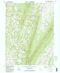
1994 Map of Big Cove Tannery
USGS Topo · Published 1997About this map
Big Cove Creek carves a narrow valley through the heart of this landscape, separating the high ridges of Scrub Ridge and Tuscarora Mountain. The settlement pattern reflects the area's early industrial and spiritual life, centered around Websters Mill and the village of Big Cove Tannery. Genealogists will find a high density of country churches and associated cemeteries marking the rural crossroads, including St Pauls Ch, Antioch Ch, and Damascus Ch. Steep topography dominates the eastern half, where Buchanan State Forest and State Game Lands No 124 preserve large tracts of timberland along the Fulton and Franklin County line. The meandering path of Licking Creek to the west creates a sequence of sharp bends and flats, such as Chestnut Flat, which provided the necessary level ground for isolated homesteads and small agricultural clearings like The Lockings.
Find a feature on this map
42 named features on this map. Tap any name to fly to it.
Don’t see what you’re looking for? This feature index may not catch every label — zoom into the map to look around manually.
Map Details
Editions of this 1994 Big Cove Tannery Map
This is the sole edition of this map. No revisions or reprints were ever made.
Other maps of this area

1899 · Hancock
USGS Topo · 1:62,500

1900 · Mercersburg
USGS Topo · 1:62,500

1901 · Hancock
USGS Topo · 1:62,500

1902 · Mercersburg
USGS Topo · 1:62,500

1912 · Williamsport
USGS Topo · 1:62,500

1925 · Needmore
USGS Topo · 1:48,000

1935 · Needmore
USGS Topo · 1:62,500

1939 · Needmore
USGS Topo · 1:62,500

1942 · Hagerstown
USGS Topo · 1:125,000

1943 · Hagerstown
USGS Topo · 1:125,000