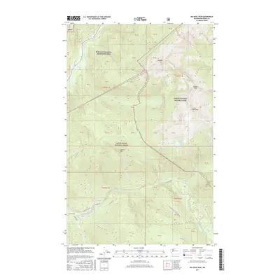
2017 Map of Big Devil Peak
USGS Topo · Published 2017About this map
Big Devil Peak and Little Devil Peak dominate the high-elevation divide where the North Cascades National Park meets the Mount Baker National Forest. This 2017 survey details a landscape defined by dramatic relief and alpine water bodies like Monogram Lake and Da-Rush Lake. The northern reach is bounded by the Ross Lake National Recreation Area and the Skagit River, while the southern portion traces the winding path of the Cascade River. Local access is represented by the Cascade River Rd and specialized forest routes such as Natl Forest Develop Road 1550 Rd. The convergence of these major protected areas and the network of drainages including Alma Cr, Marble Cr, and Irene Cr illustrates the complex hydrological and jurisdictional boundaries of the region.
Find a feature on this map
30 named features on this map. Tap any name to fly to it.
Don’t see what you’re looking for? This feature index may not catch every label — zoom into the map to look around manually.
Map Details
Editions of this 2017 Big Devil Peak Map
This is the sole edition of this map. No revisions or reprints were ever made.
Other maps of this area

1899 · Glacier Peak
USGS Topo · 1:125,000

1901 · Glacier Peak
USGS Topo · 1:125,000

1953 · Marblemount
USGS Topo · 1:62,500

1955 · Concrete
USGS Topo · 1:250,000

1958 · Concrete
USGS Topo · 1:250,000

1962 · Concrete
USGS Topo · 1:250,000

1963 · Sonny Boy Lakes
USGS Topo · 1:24,000

1963 · Eldorado Peak
USGS Topo · 1:24,000

1963 · Diablo Dam
USGS Topo · 1:24,000
1966 · Snowking Mtn.
USGS Topo · 1:24,000