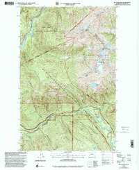
1999 Map of Big Devil Peak
USGS Topo · Published 2002About this map
Big Devil Peak and Lookout Mountain dominate the skyline of this high-elevation wilderness where the Skagit River and Cascade River systems converge. The landscape is defined by the intersections of several major federal land management areas, including the North Cascades National Park, Mt Baker-Snoqualmie National Forest, and the Ross Lake National Recreation Area. A single prospect and a remote cablecar hint at the isolated human activity in these steep drainages, while the Gaging Sta along the Skagit reflects the importance of river monitoring near Ross Lake. Below the high ridges of Teebone Ridge and the Haystack, the Marble Creek Campground provides a rare point of developed infrastructure along the southern river corridor.
Find a feature on this map
48 named features on this map. Tap any name to fly to it.
Don’t see what you’re looking for? This feature index may not catch every label — zoom into the map to look around manually.
Map Details
Editions of this 1999 Big Devil Peak Map
This is the sole edition of this map. No revisions or reprints were ever made.
Other maps of this area

1899 · Glacier Peak
USGS Topo · 1:125,000

1901 · Glacier Peak
USGS Topo · 1:125,000

1953 · Marblemount
USGS Topo · 1:62,500

1955 · Concrete
USGS Topo · 1:250,000

1958 · Concrete
USGS Topo · 1:250,000

1962 · Concrete
USGS Topo · 1:250,000

1963 · Sonny Boy Lakes
USGS Topo · 1:24,000

1963 · Eldorado Peak
USGS Topo · 1:24,000

1963 · Diablo Dam
USGS Topo · 1:24,000
1966 · Snowking Mtn.
USGS Topo · 1:24,000