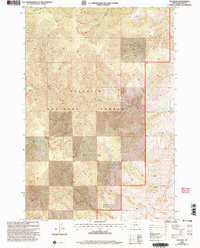
2000 Map of Big Draw
USGS Topo · Published 2005About this map
Gallatin National Forest dominates this landscape in southern Montana, defined by the drainage systems that carve through the high country. The topography is marked by significant hydrological features including the headwaters of the North Fork and South Fork, along with the secluded Mud Lake. The interior of the forest contains curiously named landmarks like Point Stupid, which stands above a network of ravines and seasonal water sources such as Dry Spring.
Find a feature on this map
15 named features on this map. Tap any name to fly to it.
Don’t see what you’re looking for? This feature index may not catch every label — zoom into the map to look around manually.
Map Details
Editions of this 2000 Big Draw Map
This is the sole edition of this map. No revisions or reprints were ever made.
Other maps of this area

1891 · Livingston
USGS Topo · 1:250,000

1893 · Livingston
USGS Topo · 1:250,000

1947 · Bozeman
USGS Topo · 1:250,000

1948 · Bozeman
USGS Topo · 1:250,000

1951 · Bozeman Pass
USGS Topo · 1:62,500

1951 · Chimney Rock
USGS Topo · 1:24,000

1955 · Bozeman
USGS Topo · 1:250,000

1955 · Emigrant
USGS Topo · 1:62,500

1955 · Fridley Peak
USGS Topo · 1:62,500

1958 · Bozeman
USGS Topo · 1:250,000