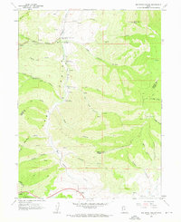
1961 Map of Big Dutch Hollow
USGS Topo · Published 1963About this map
Little Emigration Canyon and East Canyon dominate this mountainous landscape where early western passage is marked by the paths of the Donner-Reed Party and Pioneers. This 1961 survey provides a clear view of the high-altitude terrain at the border of Morgan and Summit Counties, punctuated by historical markers that trace the movement of early settlers through the Wasatch Range. Notable sites include Mormon Flat Historical Marker and the Bauhmanns Pony Express Station Historical Marker, locating where the mail and the wagon trains once found safe harbor. To the south, small outposts like Gorgoza and Altus sit along the primary road leading toward Parleys Canyon. The map records the complex drainage of the area, from the winding Big Dutch Hollow to the seasonal courses of Schuster Cr and Dry Fork, showing the natural obstacles faced by those following the historic trail routes.
Find a feature on this map
47 named features on this map. Tap any name to fly to it.
Don’t see what you’re looking for? This feature index may not catch every label — zoom into the map to look around manually.
Map Details
Editions of this 1961 Big Dutch Hollow Map
3 editions found
Other maps of this area

1885 · Salt Lake
USGS Topo · 1:250,000

1900 · Coalville
USGS Topo · 1:125,000

1903 · Coalville
USGS Topo · 1:125,000

1925 · Ft. Douglas
USGS Topo · 1:125,000

1928 · Ft. Douglas
USGS Topo · 1:125,000

1954 · Salt Lake City
USGS Topo · 1:250,000

1955 · Park City East
USGS Topo · 1:24,000

1955 · Mount Aire
USGS Topo · 1:24,000

1955 · Park City West
USGS Topo · 1:24,000

1958 · Salt Lake City
USGS Topo · 1:250,000