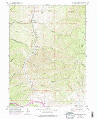
1961 Map of Big Dutch Hollow
USGS Topo · Published 1978About this map
Historic migration routes and early pioneer landmarks define this rugged stretch of the Wasatch Range along the borders of Morgan, Summit, and Salt Lake Counties. The map documents the path of the Pioneers through Little Emigration Canyon and over Donner-Reed Pass, highlighting the significance of Mormon Flat Historical Marker and the Bauchmanns Pony Express Station Historical Marker. These markers, along with Historic Ruins and the Camp Clayton Historical Marker, trace the vital 19th-century transport corridor between the plains and the Salt Lake Valley.
Find a feature on this map
45 named features on this map. Tap any name to fly to it.
Don’t see what you’re looking for? This feature index may not catch every label — zoom into the map to look around manually.
Map Details
Editions of this 1961 Big Dutch Hollow Map
3 editions found
Other maps of this area

1885 · Salt Lake
USGS Topo · 1:250,000

1900 · Coalville
USGS Topo · 1:125,000

1903 · Coalville
USGS Topo · 1:125,000

1925 · Ft. Douglas
USGS Topo · 1:125,000

1928 · Ft. Douglas
USGS Topo · 1:125,000

1954 · Salt Lake City
USGS Topo · 1:250,000

1955 · Park City East
USGS Topo · 1:24,000

1955 · Mount Aire
USGS Topo · 1:24,000

1955 · Park City West
USGS Topo · 1:24,000

1958 · Salt Lake City
USGS Topo · 1:250,000