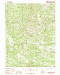
1991 Map of Big Foot Mountain
USGS Topo · Published 1991About this map
Diamond D Ranch and Rockpile Ranch anchor the remote topography of the Mendocino and Sonoma County border, illustrating the large-scale ranching operations that have long characterized this part of the California Coast Ranges. The landscape is defined by a dense network of watercourses, with Rancheria Creek winding through the northern reaches while the Wheatfield Fork Gualala River drains the southern territory. Significant elevation changes are marked by peaks such as Big Foot Mtn, Crystal Peak, and Buck Mtn. To the southeast, the waters of Lake Sonoma appear, framed by the prominent Thompson Ridge. This 1991 provisional survey captures a moment before modern development significantly altered the drainage patterns of the various canyons, including Big Foot Canyon and Franks Canyon, which provide a complex watershed for the Gualala River system.
Find a feature on this map
25 named features on this map. Tap any name to fly to it.
Don’t see what you’re looking for? This feature index may not catch every label — zoom into the map to look around manually.
Map Details
Editions of this 1991 Big Foot Mountain Map
This is the sole edition of this map. No revisions or reprints were ever made.
Other maps of this area

1921 · Skaggs
USGS Topo · 1:62,500

1921 · Plantation
USGS Topo · 1:62,500

1938 · Hopland
USGS Topo · 1:62,500

1943 · Tombs Creek
USGS Topo · 1:24,000

1943 · Annapolis
USGS Topo · 1:24,000

1943 · Skaggs Springs
USGS Topo · 1:24,000

1943 · Hopland
USGS Topo · 1:62,500

1943 · Ornbaun
USGS Topo · 1:62,500

1944 · Annapolis
USGS Topo · 1:31,680

1944 · Skaggs Springs
USGS Topo · 1:31,680