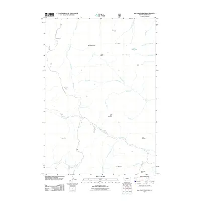
2011 Map of Big Horn Mountain
USGS Topo · Published 2011About this map
Big Horn Mountain rises as a central landmark in this high-altitude landscape of Madison County, where numerous water systems like Ruby Creek and the East Fork Ruby River drain the surrounding heights. The terrain is defined by a series of prominent ridges and peaks, including Monument Ridge, Fossil Ridge, and Marmot Mountain, which overlook the high Tepee Basin. Human presence is sparsely marked by remote landmarks and forest infrastructure, such as Reids Camp in the southwest and Sheep Camp along Usfs RD 237. The Gravelly Range Rd provides a primary corridor through this rugged section of the national forest, passing near Lazyman Hill and Red Hill. Smaller water features like Wall Creek Lake and the Klatt Dam indicate the management of mountain runoff, while labels for Wolverine Basin and Wolverine Creek highlight the wild, undisturbed character of the drainages in the southeastern quadrant.
Find a feature on this map
36 named features on this map. Tap any name to fly to it.
Don’t see what you’re looking for? This feature index may not catch every label — zoom into the map to look around manually.
Map Details
Editions of this 2011 Big Horn Mountain Map
This is the sole edition of this map. No revisions or reprints were ever made.
Other maps of this area

1888 · Three Forks
USGS Topo · 1:250,000

1894 · Three Forks
USGS Topo · 1:250,000

1895 · Three Forks
USGS Topo · 1:250,000

1947 · Bozeman
USGS Topo · 1:250,000

1948 · Bozeman
USGS Topo · 1:250,000

1949 · Varney
USGS Topo · 1:62,500

1950 · Cliff Lake
USGS Topo · 1:62,500

1950 · Cameron
USGS Topo · 1:62,500

1950 · Monument Ridge
USGS Topo · 1:62,500

1955 · Bozeman
USGS Topo · 1:250,000