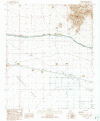
1990 Map of Big Horn Peak
USGS Topo · Published 1990About this map
Big Horn Mountains terrain dominates the northeastern portion of this Maricopa County landscape, centered on the prominent summit of Big Horn Peak. As of this 1986 field check, the southern expanse is defined by the Harquahala Plain, an area managed through a network of Wells, Check Dams, and the massive Granite Reef Aqueduct. The presence of several Mine Shafts and prospects near the mountain base points to a history of mineral exploration, while the southern infrastructure, including a Landing Strip and Feed Lot, reflects the region's mid-century transition toward larger-scale agricultural and ranching operations. The aqueduct serves as a major dividing line between the high desert peaks and the irrigation-dependent plains below.
Find a feature on this map
19 named features on this map. Tap any name to fly to it.
Don’t see what you’re looking for? This feature index may not catch every label — zoom into the map to look around manually.
Map Details
Editions of this 1990 Big Horn Peak Map
This is the sole edition of this map. No revisions or reprints were ever made.
Other maps of this area

1942 · Vicksburg
USGS Topo · 1:250,000

1954 · Phoenix
USGS Topo · 1:250,000

1957 · Phoenix
USGS Topo · 1:250,000

1958 · Phoenix
USGS Topo · 1:250,000

1960 · Phoenix
USGS Topo · 1:250,000

1961 · Lone Mountain
USGS Topo · 1:62,500

1961 · Big Horn Mts
USGS Topo · 1:62,500

1962 · Cortez Peak
USGS Topo · 1:62,500

1962 · Eagletail Mts
USGS Topo · 1:62,500

1969 · Phoenix
USGS Topo · 1:250,000