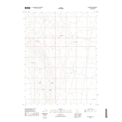
2020 Map of Big Horseshoe
USGS Topo · Published 2020About this map
Confusion Range topography dominates this section of Millard County, where a complex network of high ridges and narrow passes defines the West Desert landscape. The terrain is marked by distinctive geological formations such as Chevron Ridge and the curved landforms of Big Horseshoe and Little Horseshoe. These features, along with the steep Plympton Ridge, create a natural corridor through Indian Pass.
Find a feature on this map
11 named features on this map. Tap any name to fly to it.
Don’t see what you’re looking for? This feature index may not catch every label — zoom into the map to look around manually.
Map Details
Editions of this 2020 Big Horseshoe Map
This is the sole edition of this map. No revisions or reprints were ever made.
Other maps of this area

1908 · Fish Springs
USGS Topo · 1:250,000

1910 · Fish Springs
USGS Topo · 1:250,000

1953 · Delta
USGS Topo · 1:250,000

1958 · Delta
USGS Topo · 1:250,000

1959 · Cowboy Pass
USGS Topo · 1:62,500

1960 · Granite Mountain
USGS Topo · 1:62,500

1960 · Gandy
USGS Topo · 1:62,500

1961 · Trout Creek
USGS Topo · 1:62,500

1962 · Delta
USGS Topo · 1:250,000
1979 · Fish Springs
USGS Topo · 1:100,000