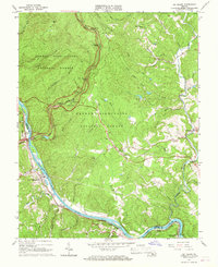
1965 Map of Big Island
USGS Topo · Published 1967About this map
The James River and Pedlar River converge in this mid-1960s survey, marking a rugged landscape where the Blue Ridge meets industrial transit lines. The Chesapeake and Ohio Rwy follows the northern bank of the James, connecting small riverfront communities like Big Island, Waugh, and Coleman Falls. Much of the western terrain is preserved within the George Washington National Forest, where the Blue Ridge Parkway snakes past several scenic overlooks, including The Riffles Overlook and Terrapin Hill Overlook.
Find a feature on this map
65 named features on this map. Tap any name to fly to it.
Don’t see what you’re looking for? This feature index may not catch every label — zoom into the map to look around manually.
Map Details
Editions of this 1965 Big Island Map
Other maps of this area

1892 · Lynchburg
USGS Topo · 1:125,000

1894 · Lexington
USGS Topo · 1:125,000

1935 · Buena Vista
USGS Topo · 1:48,000

1935 · Amherst
USGS Topo · 1:48,000

1939 · Amherst
USGS Topo · 1:62,500

1939 · Buena Vista
USGS Topo · 1:62,500

1940 · Buena Vista
USGS Topo · 1:62,500

1944 · Lynchburg
USGS Topo · 1:62,500

1947 · Roanoke
USGS Topo · 1:250,000

1950 · Goode
USGS Topo · 1:62,500