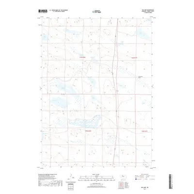
2017 Map of Big Lake
USGS Topo · Published 2017About this map
The expansive Goose Cr drainage and a dense network of Sandhills lakes define this portion of Cherry County. The landscape is characterized by its significant wetland systems, including Vrender Swamp and Pearson Swamp, which sit alongside prominent water bodies like Big Lake and South Marsh Lake. This 2017 survey reflects the enduring cattle-country geography of the Nebraska Sandhills, where drainage patterns and localized valleys like Sweetwater Valley dictate the placement of ranch infrastructure. These basins, such as Tate Lake, Dads Lake, and Pony Lake, provide essential water sources in a region where surface water is the primary organizing force for human activity and natural habitat. The map also identifies specific family-named landmarks like Campbell Lake, Homestead Lake, and Durbin Lake, offering a detailed record of the local hydrology and land use at the start of the twenty-first century.
Find a feature on this map
19 named features on this map. Tap any name to fly to it.
Don’t see what you’re looking for? This feature index may not catch every label — zoom into the map to look around manually.
Map Details
Editions of this 2017 Big Lake Map
This is the sole edition of this map. No revisions or reprints were ever made.
Other maps of this area

1949 · Long Lake
USGS Topo · 1:62,500

1950 · Simeon
USGS Topo · 1:62,500

1950 · Arabia
USGS Topo · 1:62,500

1951 · Long Lake
USGS Topo · 1:62,500

1951 · Brownlee
USGS Topo · 1:62,500

1957 · Valentine
USGS Topo · 1:250,000

1959 · Valentine
USGS Topo · 1:250,000

1985 · Long Lake
USGS Topo · 1:24,000
1985 · Arabia SW
USGS Topo · 1:24,000

1985 · Goose Creek
USGS Topo · 1:100,000