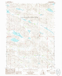
1985 Map of Big Lake
USGS Topo · Published 1986About this map
The Valentine National Wildlife Refuge dominates this section of the Nebraska Sandhills, protecting a complex network of freshwater lakes and wetlands. Grounded in the mid-1980s, the map reveals a landscape defined by water and grass, where large bodies like Big Lake and Dads Lake are interspersed among smaller basins such as Lost Lake and Pony Lake. The presence of the Vian Ranch underscores the region's sparse ranching footprint amidst the protected prairie. In the southern portion of the sheet, the headwaters of Goose Creek meander through a broad drainage area, bordered by the Pearson Swamp and Chamberlain Swamp. This topography highlights the vital role of the Ogallala Aquifer in maintaining the Sweetwater Valley and its surrounding marshlands, which serve as essential habitat for migratory birds and local wildlife.
Find a feature on this map
20 named features on this map. Tap any name to fly to it.
Don’t see what you’re looking for? This feature index may not catch every label — zoom into the map to look around manually.
Map Details
Editions of this 1985 Big Lake Map
This is the sole edition of this map. No revisions or reprints were ever made.
Other maps of this area

1949 · Long Lake
USGS Topo · 1:62,500

1950 · Simeon
USGS Topo · 1:62,500

1950 · Arabia
USGS Topo · 1:62,500

1951 · Long Lake
USGS Topo · 1:62,500

1951 · Brownlee
USGS Topo · 1:62,500

1957 · Valentine
USGS Topo · 1:250,000

1959 · Valentine
USGS Topo · 1:250,000

1985 · Long Lake
USGS Topo · 1:24,000
1985 · Arabia SW
USGS Topo · 1:24,000

1985 · Goose Creek
USGS Topo · 1:100,000