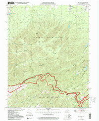
1999 Map of Big Levels
USGS Topo · Published 2000About this map
George Washington National Forest encompasses the high ridges of the Blue Ridge mountains along the border of Augusta and Nelson Counties. The Blue Ridge Parkway winds through the southern portion of the map, punctuated by several scenic vantage points such as The Slacks Overlook and the Twenty Minute Cliff Overlook. This landscape transition is defined by the steep elevation changes from the valley floor near Shenandoah Acres to the high plateau of the Big Levels.
Find a feature on this map
61 named features on this map. Tap any name to fly to it.
Don’t see what you’re looking for? This feature index may not catch every label — zoom into the map to look around manually.
Map Details
Editions of this 1999 Big Levels Map
This is the sole edition of this map. No revisions or reprints were ever made.
Other maps of this area

1892 · Buckingham
USGS Topo · 1:125,000

1892 · Harrisonburg
USGS Topo · 1:125,000

1894 · Staunton
USGS Topo · 1:125,000

1894 · Lexington
USGS Topo · 1:125,000

1934 · Waynesboro
USGS Topo · 1:48,000

1936 · Vesuvius
USGS Topo · 1:48,000

1939 · Waynesboro
USGS Topo · 1:62,500

1941 · Vesuvius
USGS Topo · 1:62,500

1943 · Lovingston
USGS Topo · 1:62,500

1944 · Staunton
USGS Topo · 1:62,500