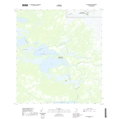
2021 Map of Big Lostmans Bay
USGS Topo · Published 2021About this map
Everglades National Park and Big Cypress National Preserve meet in this aquatic wilderness, where the distinction between land and water is often defined by mangrove fringes and hammocks. The map details a complex hydrographic network dominated by Big Lostmans Bay and Rodgers River Bay, illustrating the tidal influence on the Florida coast before these waters reach the Gulf of Mexico. Navigation through these wetlands is marked by the Wilderness Waterway Trl and Everglades Paddling Trl, which thread through passages like The Cutoff and Rodgers Creek. Terrestrial features are sparse but significant, including the elevated Cocoanut Hammock in the north and Cabbage Island to the south. This survey captures a landscape almost entirely devoid of modern infrastructure, preserving the original character of The Everglades as a vast, interconnected drainage system of sloughs like Lostmans Slough and slow-moving rivers.
Find a feature on this map
25 named features on this map. Tap any name to fly to it.
Don’t see what you’re looking for? This feature index may not catch every label — zoom into the map to look around manually.
Map Details
Editions of this 2021 Big Lostmans Bay Map
This is the sole edition of this map. No revisions or reprints were ever made.
Other maps of this area

1956 · Miami
USGS Topo · 1:250,000

1958 · Miami
USGS Topo · 1:250,000

1972 · Harney River
USGS Topo · 1:24,000

1972 · Lostmans Trail
USGS Topo · 1:24,000

1972 · Big Boy Lake
USGS Topo · 1:24,000

1972 · Tarpon Bay
USGS Topo · 1:24,000

1972 · Indian Camp Creek
USGS Topo · 1:24,000

1972 · Shark Point
USGS Topo · 1:24,000

1973 · Big Lostmans Bay
USGS Topo · 1:24,000

1973 · Lostmans River Ranger Station
USGS Topo · 1:24,000