
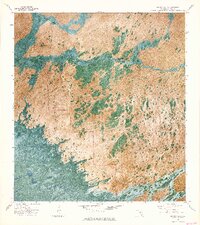
1972 Map of Big Boy Lake
USGS Topo · Published 1976About this map
Everglades National Park in Monroe County reveals the intricate, water-dominated geography of the Florida wetlands as they were documented in the early 1970s. This orthophotomap combines traditional topographic data with aerial photography, capturing the specific distribution of hammocks and strands that define the interior glades. Named landmarks like Charley Jumper Hammock and Sig Walker Strand reflect the historical presence of Seminole and early settler families who navigated this landscape long before its formal preservation.
Find a feature on this map
14 named features on this map. Tap any name to fly to it.
Don’t see what you’re looking for? This feature index may not catch every label — zoom into the map to look around manually.
Map Details
Editions of this 1972 Big Boy Lake Map
2 editions found
Other maps of this area

1956 · Miami
USGS Topo · 1:250,000

1958 · Miami
USGS Topo · 1:250,000

1972 · Lostmans Trail
USGS Topo · 1:24,000

1972 · Indian Camp Creek
USGS Topo · 1:24,000

1973 · Gator Hook Swamp
USGS Topo · 1:24,000

1973 · Fiftymile Bend
USGS Topo · 1:24,000

1973 · Monroe Station
USGS Topo · 1:24,000

1973 · Big Lostmans Bay
USGS Topo · 1:24,000

1973 · Lostmans River Ranger Station
USGS Topo · 1:24,000

1973 · Alligator Bay
USGS Topo · 1:24,000