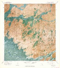
1972 Map of Big Boy Lake
USGS Topo · Published 1976About this map
Everglades National Park covers this 1970s orthophotomap, showing the complex hydrology and vegetation patterns of the Florida wetlands before modern ecological restoration efforts. The landscape is a mosaic of cypress strands and open water, punctuated by higher ground like Charley Jumper Hammock. This specific survey period captures the area’s dependence on specialized transport, with an Airboat Trail and Sawmill Road providing rare points of access through the Lostmans Pines. The transition between different wetland ecosystems is visible in the shift from Sig Walker Strand into the open waters of Big Boy Lake. These intricate drainage patterns, including Gum Slough and Five Lostmans Slough, reveal the natural flow of the southern glades during an era of significant environmental study.
Find a feature on this map
13 named features on this map. Tap any name to fly to it.
Don’t see what you’re looking for? This feature index may not catch every label — zoom into the map to look around manually.
Map Details
Editions of this 1972 Big Boy Lake Map
2 editions found
Other maps of this area

1956 · Miami
USGS Topo · 1:250,000

1958 · Miami
USGS Topo · 1:250,000

1972 · Lostmans Trail
USGS Topo · 1:24,000

1972 · Big Boy Lake
USGS Topo · 1:24,000

1972 · Indian Camp Creek
USGS Topo · 1:24,000

1973 · Gator Hook Swamp
USGS Topo · 1:24,000

1973 · Fiftymile Bend
USGS Topo · 1:24,000

1973 · Monroe Station
USGS Topo · 1:24,000

1973 · Big Lostmans Bay
USGS Topo · 1:24,000

1973 · Lostmans River Ranger Station
USGS Topo · 1:24,000