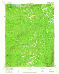
1956 Map of Big Meadow
USGS Topo · Published 1962About this map
The Calaveras Big Trees State Park (South Grove) anchors the southwestern corner of this Sierra Nevada landscape, where the high country transitions into the dense forests of the Eldorado National Forest and Stanislaus National Forest. In the mid-1950s, this region remained a network of high-altitude summer camps and cattle range, evidenced by numerous named stations such as Cuneo Camp, Sapps Camp, and Lombardi. The mapping of Bloods Toll Sta (Site) near Bear Valley marks a historical passage through the mountains, while more remote outposts like Brown Girl Cabin and Brown Boy Cabin indicate the scattered presence of seasonal inhabitants or forest workers. The drainage patterns are dominated by the North Fork Mokelumne River and the Middle Fork Stanislaus River, which carve deep canyons through terrain marked by landmarks like Calaveras Dome and Whittakers Dardanelles. A Logging RR fragment near the North Fork Beaver Creek suggests the era's active timber industry.
Find a feature on this map
96 named features on this map. Tap any name to fly to it.
Don’t see what you’re looking for? This feature index may not catch every label — zoom into the map to look around manually.
Map Details
Editions of this 1956 Big Meadow Map
4 editions found
Other maps of this area

1889 · Pyramid Peak
USGS Topo · 1:125,000

1889 · Markleeville
USGS Topo · 1:125,000

1891 · Markleeville
USGS Topo · 1:125,000

1891 · Big Trees
USGS Topo · 1:125,000

1891 · Pyramid Peak
USGS Topo · 1:125,000

1893 · Markleeville
USGS Topo · 1:125,000

1894 · Big Trees
USGS Topo · 1:125,000

1895 · Pyramid Peak
USGS Topo · 1:125,000

1896 · Dardanelles
USGS Topo · 1:125,000

1896 · Pyramid Peak
USGS Topo · 1:125,000